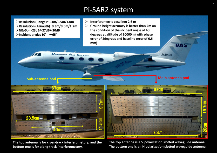
Pi-SAR2 system

- Resolution (Range):0.3m/0.5m/1.0m
- Resolution (Azimuth):0.3m/0.6m/1.2m
- NEσ0:< -23dB/-27dB/-30dB
- Incident angle:10°~65°
- Interferometric baseline: 2.6 m
- Ground height accuracy is better than
- 2m on the condition of the incident angle of 40 degrees at altitude of 10000m (with phase error of 2degrees and baseline error of 0.5 mm)
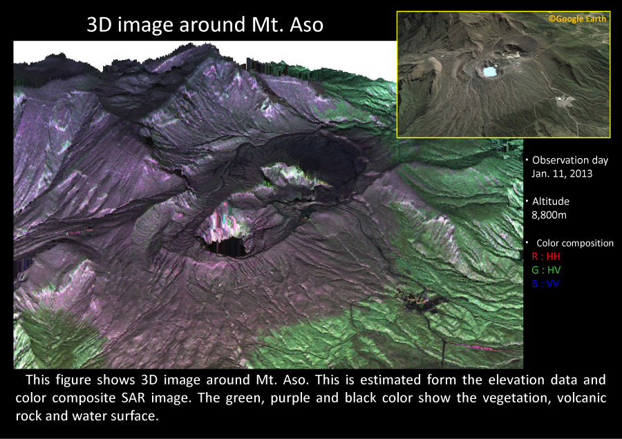
3D image around Mt. Aso

This figure shows 3D image around Mt. Aso. This is estimated form the elevation data and color composite SAR image. The green, purple and black color show the vegetation, volcanic rock and water surface.
3D image around Mt. Shinmoe

The lower figure shows 3D image around Mt. Shinmoe. This image is created from the elevation data and color composite SAR image.
Information
システムメンテナンスのお知らせ[2026.02.09] 2/9-2/12にシステムメンテンスを行います。 |
処理計算機更新について[2024.01.26] Pi-SARとPi-SAR2関連の処理計算機の更新を行いました。これに伴い、2024年1月26日以前とのL1処理データについて、今後以下の差異を生じることがあります。なお、更新前後の事前評価の結果、今回の差異については2011年度にCPU処理からGPU処理へ変更した際の差異と同程度でした。 |
注文受付再開のお知らせ[2023.05.11] システム障害が解消しましたので注文受付を再開致しました。ご迷惑をお掛けいたしました。なおタイムアウトエラーにつながる恐れがあるため、 |
処理計算機更新について[2022.02.24] Pi-SAR2関連の処理計算機の更新を行いました。これに伴い、2022年2月22日以前とのL1処理データについて、今後以下の差異を生じることがあります。なお、更新後と同型の計算機による事前評価の結果、今回の差異については2011年度にCPU処理からGPU処理へ変更した際の差異と同程度でした。また、一部のデータを用いて干渉性も確認しています。 |
Webシステムの実運用開始[2015.10.01] 航空機搭載合成開口レーダ観測検索システムの実運用を2015年10月1日から開始しました。本システムではPi-SAR及びPi-SAR2の試験観測及び緊急観測で得られたデー タを登録したユーザに提供するものです。利用については、利用規約(URL : https://pi-sar.nict.go.jp/create_user_request.php)を御覧ください。 |
Webシステムの試験公開開始[2014.03.20] 公募研究PIを対象とした航空機搭載合成開口レーダ観測検索システムの試験運用を開始しました。航空機搭載合成開口レーダ観測検索システムの実運用は2015年10月頃を予定しています。試験運用期間中、本システムは限定ユーザのみが利用できます。 |


